Thursday, August 11, 2005
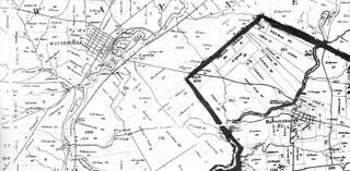
Click on the map to enlarge.
Between Waynesville/Corwin and Harveysburg there is rich farm land. In the past, as one traveled east from Waynesville, the land dropped down into a steep and wide valley, the valley of Caesar's Creek. High on the eastern ridge overlooking the valley was Harveysburg located on the main road between Wilmington and Waynesville, Ohio. This road, which was once the Main Street of Harveysburg, is now State Rte 73. However, it has been diverted around Harveysburg twice over the years. Before these diversions, Harveysburg was famous for the famous "S"curve that lead up from the bottom of the valley into the village.


0 Comments:
Post a Comment
<< Home